EXCAVATIONS AT
THE BERGER SITE (LAN-206):
A PREHISTORIC MILLINGSTONE AND
INTERMEDIATE DEPOSIT
IN THE CITY OF LOS ANGELES
by
David M. Van
Horn, Laurie S. White, Lee A. DiGregorio,
Susan
M. Colby, and Roy A. Salls
March
2003
This internet presentation of the Berger
site report is a slightly edited version of an earlier report
produced by Archaeological Associates in September of 1997.
Originally, the archaeological deposit covered a prominent hilltop
and the encircling slopes. When we first visited the location,
it consisted of one undeveloped residential lot on the hilltop
(Lan-206) and a peripheral scatter on the northerly slope across 80th
Street (Lan-206"A"). The remainder of the site had
been destroyed by development.
The surviving deposit contained evidence
of both Millingstone and Intermediate Horizon use. It has
yielded the earliest C-14 date of any of the complex of
archaeological deposits on the Ballona bluffs. Moreover, the
results of faunal analyses seem to indicate a sharp change in food
preference during the period of the site's use. For these and
other reasons, we felt that the Berger investigations merited
internet publication.
CONTENTS
I.
INTRODUCTION
II. BACKGROUND INFORMATION
III. SUMMARY OF
EXCAVATIONS AT THE
BERGER SITE
(LAN-206)
A. Introduction
B. Excavations
C.
Finds
D. Faunal Analyses
E. Chronometric Data
IV. DISCUSSION AND CONCLUSIONS
V. INVESTIGATIONS AT LAN-206A
ON THE
NORTH SLOPE (WEST BLUFF PROPERTY)
A. Surface Scatter at LAN-206A
B. Test Excavation
Units
C. Interpretation of LAN-206
D. Evaluation
of the Significance of LAN-206A
REFERENCES CITED
I. INTRODUCTION
LAN-206,
the Berger site, was a prehistoric archaeological deposit located on
the top of a low hill about 1,500 feet south of the edge of the
Ballona bluffs in the Westchester area of the City of Los Angeles.
It was probably the most ancient of a string of archaeological sites
which once ran the full length of the bluffs overlooking the Ballona
Creek wetlands. The hilltop was bladed off between 1984-1985 to
accommodate residential development. However, considerable
information was gathered by test excavation and volunteer teams prior
to grading.
Because the deposit was situated on a hilltop, some
cultural debris had scattered down the slope to the north. The
outer portion of this material extended onto the southwestern corner
of the West Bluff property. The purposes of this report are to:
(1) summarize what is known about the Berger site and (2) to provide
details regarding Berger peripheral material which was found on the
West Bluff tract.
II. BACKGROUND INFORMATION
The first professionals to examine the Berger site seem
to have been Charles Rozaire and Russell Belous who visited the
location during their well-known 1950 survey of the Ballona
Escarpment. The site was officially recorded by Hal Eberhart in
1953 and re-examined by Robert Pence in 1979. Pence's comments
included the following:
Artifacts from this site included manos and metates and
cog stones...but no mortars or pestles. The lack of mortars and
pestles may indicate that the site dates to the Millingstone Period
or that it was single purpose encampment site of some later period.
The presence of cog stones would tend to argue that the site is of
Millingstone age. The area for the site is 123 meters by
62 meters. Other designations for this site are LA-24 and
William Deane's site #6. (Pence 1979:n.p.)
One of the amateurs who had known about the Berger site
for many years was William Deane. His collection was
photographically recorded by Marlys Thiel (1953; Deane's site #6).
Deane's collection included some bowl and mortar fragments
(apparently contradicting Pence's observations) in addition to three
complete and one fragmentary "cogstone," artifacts
generally believed to be reliable indicators of considerable
antiquity as noted by Pence.
In the fall of 1983, David Van Horn, John R. Murray, and
Charles Rozaire surveyed a 30-acre tract of land east of Berger Place
(Van Horn 1983). After observing the topography, it became
clear that LAN-206 had once extended eastward across the alignment of
Berger Place and onto the residential lot across the street.
However, the results of the survey showed that the site had not
extended far enough eastward for any portion to have survived
development (although two marginal shell scatters were found nearby
and subsequently tested; see Brown and Murray 1983).
III. SUMMARY OF EXCAVATIONS AT THE BERGER SITE
(LAN-206)
A. Introduction
The information which follows relates to excavations
which took place at LAN-206, an archaeological deposit which is
located south across 80th Street from the West Bluff property
(southwest corner of 80th Street and Berger Place; fig. 1). The
excavations are described here because they directly relate to
subsequent work on the West Bluff property in the area designated
LAN-206A.
Work at LAN-206 was conducted in two phases. The
first phase, which was sponsored by Howard Hughes Realty, Inc. in
1983, consisted of a limited test excavation. The second phase,
which consisted of additional hand excavation as well as machine
digging was conducted in 1984 by a volunteer team of unpaid
professionals. The volunteer work was necessary because a
grading permit for the property had been issued and the deposit was
about to be removed.
Originally, Ms. Lee A. DiGregorio planned to write her
Master's Thesis on the work at the Berger site. Although she
never completed the thesis, Ms. DiGregorio compiled the field notes,
cataloged the finds, and arranged for mapping. Thus, much of
the information which follows is based upon her work.
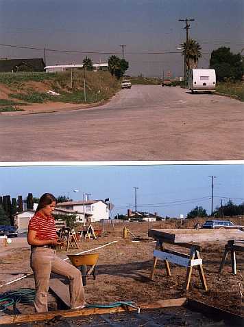 Plate
I
Plate
I
Top: Vacant lot comprising
portion of LAN-206 excavated in 1983-1984 (southwest corner of 80th
Street and Berger Place. Note: location of LAN-206A is north of
stop sign in background. Bottom: Water screening at LAN-206 in
1984.
B. Excavations
The total volume of soil excavated at LAN-206 is
calculated to be 62 cubic meters. A map showing both the 1983
and 1984 unit locations is presented as Figure 2 where it may be seen
that all areas of the hilltop were sampled.
1983: Units 1-2; 1 x 1 m. hand excavated Units 3-4; 2 x 2
m. hand excavated (Unit 4 completed in 1984)
1984:
Units 6-8; 1 x 1 m. hand excavated
Unit 5; 2 x 2 m. hand
excavated
TR 1-3; backhoe trenches totaling 48 m. in length
BH
3-5; backhoe pits totaling 16 m. in length and 2-3 m. in width
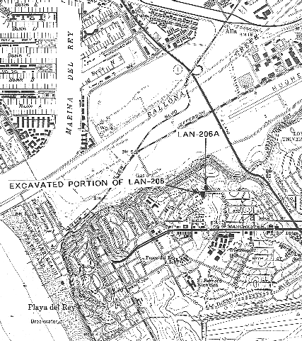
Figure 1
Location of LAN-206A and
excavated portion of LAN-206 as shown on a portion
of the
USGS Venice 7.5' Topographic Quadrangle.
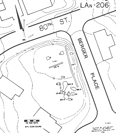
Figure 2
Site map showing locations
of excavated units and trenches at LAN-206.
Location of
LAN-206A is off map to the northeast of 80th Street and Berger Place.
The bulk of the material described in this report was
recovered from the hand excavated units. The soil in each of
these units was excavated in 10 cm. levels dug in contour with the
surface. Backdirt was hydraulically processed in screens fitted
with 1/8" mesh. Level forms were filled out in the field
and cultural materials were bagged and labeled by provenience and
stored for analysis. The total volume of the hand excavated
deposit was 12 cubic meters.
Backhoe work commenced following completion of the hand
dug units. Its purposes were to further assess the
stratigraphy, depth, and extent of the site and also to expand the
artifact inventory. In addition, it was anticipated that
features might be uncovered using this method. Since the
volunteer crew's time was limited (the backhoe operator was also a
volunteer) and since the entire deposit was about to be bladed off,
machine exploration was the only available alternative for examining
large areas of the site.
Machine dug excavations consisted of three trenches (TR
units) and three large pits (BH units), the digging of which was
closely monitored by the crew. Trench 1 spanned the site from
north to south, paralleling Berger Place. The trench was 30 m.
in length, 0.8 m. in width, and averaged 1.0 m. in depth.
Trench 2 comprised a 10 m. swath on the highest portion of the knoll
at right angles to Trench 1. It averaged 0.8 m. in depth.
Trench 3 bridged the distance between Units 6 and 7. It was 8
m. in length and averaged 0.6 m. in depth. The depth of each
trench extended below the maximum depth of cultural material.
The combined volume of all three trenches was estimated to be 34
cubic meters.
The three irregular backhoe pits were dug to expand the
area of the site where a discoidal was recovered (Unit 7).
However, few additional artifacts were recovered from the pits, the
combined volume of which was estimated at 16 cubic meters.
C. Finds
The artifacts recovered during the excavations at LAN-206
were cataloged and statistically summarized by DiGregorio. Some
of the information which follows is based upon her records while
other descriptions were written by her.
1. Groundstone
Manos (Mullers): Of 25 manos and mano fragments
recovered, only three are intact while seven more are at least
one-half preserved. Eighteen specimens are bifacial and two are
trifacial. Four of the bifacial manos are wedge-shaped when
viewed in section. Twelve exhibit pecking, probably intended to
roughen the surface to enhance its grinding capability. Three
exhibit battering suggesting use for other than milling purposes.
Eight are burned.
The raw materials from which the manos were manufactured
is of some interest since almost half (12) are fashioned from
sandstone. The remainder comprise granite (11) and siltstone
(2). Why so many manos were manufactured from relatively soft
and gritty sandstone is not known but one guess is that it relates to
the kinds of plant or animal materials being milled.
The provenience of the manos is also interesting.
While more than half were recovered from the machine-dug trenches or
the surface, eight were found at depths between 20 and 40 cm. in the
hand excavated units. The horizontal distribution was across
the entire knoll top, manos having been recorded from Units 2,3,6 and
7.
Metates (Millingstones): The metate collection
consists of eleven fragments comprising five rims and five basins
(one fragment is unidentified). Once again, sandstone is the
favored material, nine of the fragments having been manufactured from
that material. The remainder are granite and schist. Hand
excavated specimens occurred in Units 3 and 4 where most appeared
between 20 and 60 cm. depth (one was found between the surface and 20
cm. in Unit 4).
Abraders: Abraders are tools which exhibit ground
surface or facets resulting from rubbing or abrading resistant
surfaces. It is possible that these tools were used in the
manufacture of other implements such as shaping or preparing surfaces
of milling equipment.
Three specimens are classified as abraders. The
first is a quartzite cobble heel which has had all angles rounded by
abrasion. Found on the surface, its dimensions are 9 x 7.5 x
4.5 cm. The second abrader is a metavolcanic cobble section
with three abraded surfaces and a few pecking scars. It was
recovered from Unit 6 at a depth of 40 cm. (7.5 x 6 x 5 cm.).
The third item is an abrader/hammer which is triangular in section
and exhibits bifacial concave surfaces with striations (9.8 x 4.3 x 3
cm.). Found in Unit 3 at a depth of 20 cm., its rounded ends
bear scars from impacts with resistant materials.
Discoidal: A single discoidal was recovered from
Unit 7 at a depth of 30 cm. The specimen, which is intact and
in fair condition, is fashioned from well-indurated sandstone.
It measures 6 cm. in diameter and 3.3 cm. in thickness. One of
its flat surfaces grades sharply into the rim whereas the opposing
surface is more rounded. Several light-to-moderate unpatterned
scratches and gouges are present on the specimen, which may be
use-wear damage from farming activities or deterioration over time.
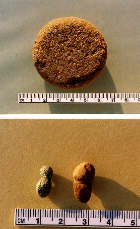
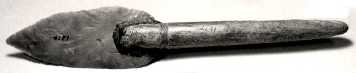
Plate II
Top: Discoidal from LAN-206,
Unit 7:30-40 cm.
Bottom: Problematic items from LAN-206
(left-Unit 3:40-50 cm., right-Unit 3:80-90 cm.).
A similar sized discoidal,
but of andesite, was reported by Lambert (1983:18, fig. 8D).
This object was found at the Bluff site (LAN-64). Van Horn and
Murray reported a discoidal from the Loyola site (LAN-61B) located on
the bluff north of Lincoln Blvd. (1985:64).
It should be noted that discoidals are often found at
sites which contain cogstones (see citations in following section).
This was also the case at the Berger site.
Cogstones: Although no cogstones were found during
excavations at the Berger site, four were collected by William Deane,
an amateur. These were photographed by Marlys Thiel and her
photographic record is preserved at UCLA (Thiel 1953:25f.; cf.
fig. 2.b). Two of these cogstones are conventional types
characterized by "gear-like" grooves ground around the
circumferences (Eberhart's "land and groove" type;
1961:362f.). The third is a rather unusual cogstone which is
roughly square in plan with pronounced incurves on the four sides.
The fourth is a fragment which we hesitate to identify from the
photograph.
A fifth cogstone was shown to the excavation crew by a
boy who said he found it on the site while digging a "fort."
This was a conventional land-and-groove type cogstone which was
photographed by Van Horn.
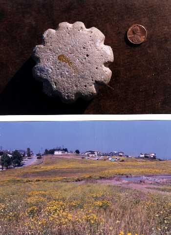
Plate III
Top: Cogstone reportedly
found at LAN-206 by boy digging "fort".
Bottom:
View of LAN-206A looking west. Site lies just south of white
house adjacent to 80th Street.
Cogstones are usually found at sites near the coast in
Orange and Los Angeles Counties although they have been reported from
as far inland as the Mojave Desert (Herring 1968:12). They are
normally found in Early Millingstone contexts (6,000-2,000 B.C.;
Wallace 1978:28; for studies of cogstones, cf. Eberhart 1961, Herring
1968, Salls 1980, Whitney-Desautels 1995). Although the
function(s) of cogstones are unknown, most writers suggest ceremonial
connections for lack of any identifiable practical use. Since
the Berger site contained no burials or other features suggesting
ritual, we are disinclined to accept this interpretation but it
cannot be ruled out.
Problematic Items (Plate II.bottom): The identity
and function of two small ground stone items is uncertain (atlatl
spurs represent a possibility). The first is a small chlorite
schist specimen (from Unit 3:40-50 cm.) which is shaped somewhat like
a bowling pin (1.35 x 0.6 x 0.5 cm.). The second item (from
Unit 3:80-90 cm.), which is red sandstone, has a bulbous "head"
and a constriction separating the head from the body of the piece.
Only 0.8 cm. of the body length survives, the remainder having been
broken away. The surviving fragment measures 1.8 x 0.9 x 0.5
cm.
Other Unidentified Groundstone Fragments: Nine
fragments are placed in the unidentified category. One
comprises a piece of pecked and ground andesite which is noteworthy
due to the hardness of the raw material. The remainder are
sandstone.
2. Chipped Stone
Cores: Thirty-seven cores are included in the
collection. Raw materials include chert (16), chalcedony (11),
metavolcanic rock (5), quartzite (3), quartz (1), and siltstone (1).
Sixteen of the chert and chalcedony specimens have been classified as
"micro-cores" because they are small (less than 2 cm. in
maximum dimension) and manufactured from fine-grained material.
Most, but not all appear to have been used to produce prismatic
debitage such as tiny bladelets or splinters (see "Drills"
below).
Other types of cores include bidirectional (7), amorphous
(12), single platform (2), and discoidal (1). While some of
these cores are chert, many are manufactured from coarser
metavolcanics. Most measure between 4 and 6 cm. in maximum
dimension. Twenty-seven cores were found in the hand excavated
units and these tended to be concentrated at depths ranging from 10
to 40 cm.
Unutilized Debitage: This category includes flakes
as well as shatter and other fragments thought to have related to the
knapping process. A grand total of 1,564 flakes were cataloged
from the excavation units. Unit 3 was by far the most
productive with a total of 986. Table 1 provides the data from
Unit 3.
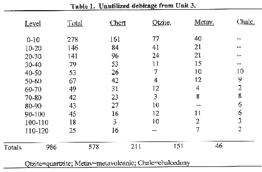
Chert is the most frequent raw material and much of this
is Monterey chert which is readily available around the nearby
Pacific shore. Metavolcanic and quartzite cobbles are also
locally available. One obsidian flake was found in Unit 3 at a
depth of 100 cm. One additional obsidian flake was found in
Trench 3. Nonetheless, the statistics from Unit 3 clearly show
that obsidian was not a significant element in the raw material
resource base of the people using the Berger site.
It is interesting to observe that unutilized debitage is
especially frequent between the surface and 30 cm. depth. This
overlaps but does not entirely correspond to the concentration of
faunal material in the vertical sequence (see "Faunal Remains"
below).
Utilized Debitage: Fifteen flakes, three of which
are prismatic, were placed in this category. Eight were
recovered from the hand excavated units (3 from Unit 3). These
items are manufactured from chert (7), metavolcanic rock (3),
quartzite (3), and chalcedony (2). A few appear to have been
deliberately retouched but most simply exhibit chipping or abrading
wear. The relatively small number of utilized specimens in
comparison to the total debitage count is somewhat surprising and
might suggest that most materials being worked were relatively soft.
Choppers: Choppers are core tools characterized by
bifacial or unifacial percussion flaked edges. They are
generally regarded as digging tools but may have served other
purposes as well. Three choppers are included in the Berger
site catalog. One is fashioned from a small andesite cobble and
has a bifacial cutting edge. A second was worked into shape
from a large metavolanic flake. Both items were found in
machine trenches. The third chopper, which was manufactured
from a large, cortical piece of quartzite, was recovered in the
90-100 cm. level of Unit 3.
Scrapers: Twenty-one scrapers are in the
collection, all having been found on the surface or in machine
trenches except for five (4 from Unit 3, 1 from Unit 2; none occurred
at more than 40 cm. in depth). Only two of the scrapers are
chert, one being a retouched flake and the other comprising a
"thumbnail scraper" which is finely flaked and may have
been manufactured from a broken point.
The remaining scrapers are larger plano-convex (10) or
flake (9) types manufactured from metavolcanics (8), or quartzite
(11). Three of these were classified as "small domed"
scrapers while two others were manufactured on cobble ends. One
quartzite specimen represents a "Teshoa flake" (i.e., a
large roundish flake which is mostly cortical on its dorsal surface).
Drills: All but one of the fifteen drills cataloged
from the Berger site were found in hand excavated units (11 in Unit 3
[0-90 cm.], 2 in Unit 2 and 1 in Unit 1). These are small tools
often referred to as "micro-drills" usually manufactured
from fine-grained materials (7 chalcedony, 7 chert, 1 quartzite).
Most are made on small splinters which are prismatic or rectangular
in cross-section. The micro-cores found at the Berger site (see
"Cores" above) may have yielded some of the drills found on
the site. The drills are pointed or chisel-shaped on the ends
and may have been used to drill holes in such items as beads or bone
shanks of multi-barbed hooks.
Biface Fragment: Originally cataloged as a "graver"
this fragment represents the edge of a Monterey chert biface.
To judge by the shape of the fragment, it represents a portion of
either the base or point of the biface. The fragment, which was
found in the 60-70 cm. level of Unit 3, measures 1.6 x 0.8 x 0.6 cm.
Point: The only projectile point known from the
Berger site is a basal fragment found on the surface. The
specimen is a portion of a side-notched point which was manufactured
from Monterey chert. While one notch is well-defined, the other
is shallow and poorly defined. Judging by the size of the
fragment (1.8 x 1.7 x 0.7 cm.), the point may have been hafted on an
atlatl dart.
3. Miscellaneous Items
Hammerstones: A total of 32 specimens were placed
in the hammerstone category. They are divided into three
groups: 26 core hammers, 2 cobble hammers, and four fragments.
The core hammers are remarkably consistent in appearance. They
tend to be round to oval in plan and roughly triangular in section
with 21 of 26 ranging from 4 to 6 cm. in length. Generally,
they retain at least 50% of their cortical surface and exhibit
moderate-to-heavy impact scars on perimeters, projections, and
arrises between flake scars.
All but two of the hammers are either quartzite or
metavolcanic rock (the two exceptions are granite and siltstone).
It is interesting to observe that of the 18 excavated hammers, 17
were recovered above 50 cm. in depth. Thus, hammers, like
milling equipment, are concentrated in the upper potion of the
vertical sequence. This may not be surprising since the hammers
were probably mostly used to roughen milling surfaces to enhance the
grinding characteristics.
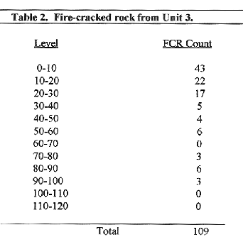
Fire-Cracked Rock: Fire-cracked rock (FCR) occurred
everywhere in the matrix of the Berger site. For the most part,
these rocks were not recorded. However, in order to have a
vertical index of FCR frequency, these rocks were counted in the
levels of Unit 3. The results can be found in Table 2.
FCR comprise the same rocks from which the milling
equipment was manufactured (granite, sandstone, quartzite, etc.).
Their distribution across the vertical sequence is noteworthy since
they are clearly concentrated in the upper 30 cm.
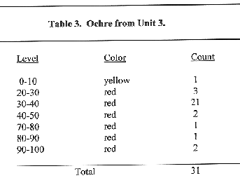
Ochre: Ochre, an extremely soft mudstone of sedimentary
origin is composed of high concentrations of iron oxides which
produce various colors in the material. Ochre is believed to
have been ground into powder to make pigments for paint.
Numerous small pieces of ochre were recorded across the vertical
sequence of Unit 3 (Table 3). It may be noteworthy that the
only level to yield a statistically significant quantity of ochre was
30-40 cm. This point in the vertical sequence is slightly below
the corresponding area for FCR (see Table 2 above).
Asphaltum & Tar Rock (by Lee A. DiGregorio):
One chunk of asphaltum measuring 4 cm. in diameter was recovered from
Unit 3 within 10 cm. of the surface. Also, a crazed angular
rock, measuring roughly 4 x 3.5 cm., was coated with asphaltum.
It was found in backhoe Trench 3.
Human (?) Tooth: A molar believed by the field
staff to be human occurred in two pieces in the 40-50 cm. level of
Unit 3. However, this tooth has not been submitted to an expert
for identification.
Modern Debris: The distribution of modern debris
across the vertical sequence is of interest because it illustrates
how much mixing due to rodents and other forms of disturbance have
taken place over a relatively short period of time.
Glass fragments were found in the 30-40 and 50-60 cm.
levels of Unit 1 and the 60-70 cm. level of Unit 4. A "Federal
Hi-Power" 12-gauge shotgun shell base was recovered from the
70-80 cm. level of Unit 4 and a .22 caliber rimfire case was found in
the 30-40 cm. level of Unit 6. On the other hand, modern
material occurred only as deep as 20 cm. in Unit 3 (plate glass, a
nail, and a piece of plastic).
D. Faunal Analyses
1. Faunal Remains (Susan M. Colby [1986])
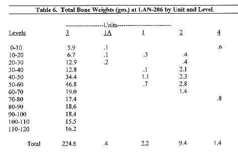
A total of 238 grams of faunal remains from 5 units at
LAN-206 were submitted for analysis [this included 0.4 gm. from Unit
1A at LAN-206A; see Section V below]. The largest sample by far
was from Unit 3 (224.6 gm.) representing 94% of the total bones from
the site. Therefore, the following analysis will be based
primarily on the Unit 3 data.
The faunal remains from all the units were highly
fragmented permitting the identification of less than 14% of the site
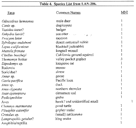
total (by weight). The identified taxa are listed in Table 4.
The sample is too small to generalize with confidence on the relative
importance of various species to the diet. However, the variety
of species present indicates that a broad spectrum of resources was
utilized including many small animals. If the samples is
representative, it reflects opportunistic hunting of locally abundant
resources, rather than specialized hunting far afield.
Approximately half of the specimens were burnt indicating
roasting as a common method of meat preparation. Burned
specimens of raccoon, dog/coyote, rabbit, hare, turtle,
bird,
snake, squirrel (and perhaps badger and sea otter) indicate these
taxa were used for food. The one identifiable deer specimen was
not burnt but it is probable that a high percentage of the large
unidentifiable mammal bones (43% of which were burnt) represent deer
(Table 5).
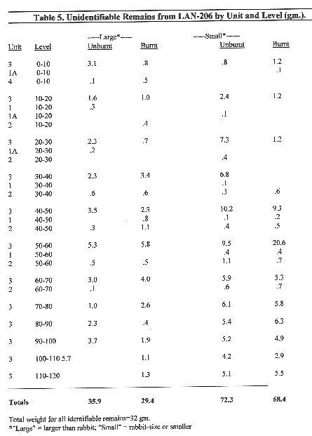
On the other hand, many of the small animal bones
probably represent intrusive events. There are no burnt
specimens of gopher, rat/mouse or weasel. However, since
approximately 49% of the unidentifiable small animal bones were burnt
(Table 5), we can surmise that at least half of the remains of small
animals (and probably more) do represent food refuse.
The remains are densest from 40-60 cm. in depth (Table 6)
with a constant but lower density from 60-120 cm. This profile
is consistent with an interpretation that this was a campsite used
repeatedly over a long period of time to utilize the abundant and
varied local resources.
The duck, goose, loon and grebe specimens represent marsh
feeders most common in the area in late fall to spring.
However, use of the site in summer as well cannot be ruled out.
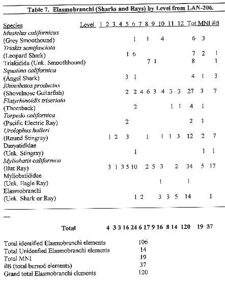
2. Fish Fauna (based on a study by Roy A. Salls
[1986])
The fish faunal elements from the Berger site
consisted of 185 elements representing a minimum number of
individuals (MNI) of 57. The sample yielded three species of
sharks, five species of rays, and eleven species of bony fishes.
The data are summarized in Tables 7 and 8 where it may be seen that
fish remains were especially plentiful in the 50-100 cm. levels.
Fish bone was recovered only from Units 1, 2 and 3.

Underwater surveys and species observations within all
possible catchment areas for LAN-206, based on Allen's (1985)
research, disclose that the fishing activity was conducted in two
local nearshore marine environments: (1) open coast sandy beach
and (2) bay and estuary. There is no evidence of pelagic
fishing at LAN-206. The fish in the faunal assemblage do not
even indicate a necessity for watercraft. Balsas would have
improved the estuary catch; however weirs and nets were the probable
method of capture.
3. Shellfish Remains (by Lee A. DiGregorio)
Marine shell was separated from the other excavated
material after it had been washed through 1/8th-inch mesh. The
shell was dried, bagged, and labeled. The next step was to
identify and count diagnostic portions of the valves for further
analysis. For bivalve species, at least half of the umbo and
hinge teeth portion had to be intact to represent one valve; the apex
was required for the univalve species. All counts used in the
analysis were based exclusively on these diagnostic portions.
Shell was separated by species using several reference
publications for identification (Morris 1966, Abbott 1968, Reish
1972; these were also used for habitat information). The shell
was very fragmented and chalky in the upper levels while the lower
levels, where most of the shell was concentrated, exhibited many
whole valves with an intact outer layer (periostracum).
A total of 776 diagnostic specimens of shell were counted
from the Berger site. These "diagnostics" plus the
identifiable fragments represent 15 species of marine shellfish.
It is apparent that only five of the species were purposefully
collected for food by the occupants of the site. All, save one,
would have been available on the mud flats and intertidal zone of the
nearby estuary. The single exception is the bean clam (Donax
c.) which is represented by only one valve; it is commonly found in
the surf zone of the open coast.
The five predominant species of marine shell divide into
three common shellfish types: Venus clam or cockle (Chione sp.)
followed by the Speckeled scallop (Plagioctenum circularis), and
Native oyster (Ostrea lurida). Since these three groups
comprise 98% of the shell collection, they are the focus of further
analysis.
By far the most favored species was the venus clam or
cockle followed by scallop and oyster. All but eight specimens
were recovered from Unit 3 which serves to illustrate that marine
shell was concentrated in the northern portion of the site.
Table 9 provides the provenience, frequency, and percentage of each
of the three primary genera in Unit 3.
The vertical distribution reveals that few shells were
recovered within the first 50 cm. of depth, but the count
dramatically increased from 50 cm. to 90 cm., then began to
diminish. Thus, few shells were visible on the surface to
indicate the presence of a buried shell midden.

E. Chronometric Data
1. Radiocarbon
A sample of marine shell (Chione sp.) was excavated from
Unit 1 between 50 and 60 cm. below the surface. It was
submitted to Beta Analytic, Inc. for radiocarbon analysis. The
sample, which weighed 42.83 gm., yielded a date of 6750 B.P.
Since the Beta lab "normalized" the result,
that is, it contains an implied reservoir correction of 410 years,
the magnitude of correction is reduced from 680 + 15 to 270 + 15.
The reservoir corrected date then becomes 6480 B.P or 4530 B.C.
2. Obsidian Hydration
Of the two flakes of obsidian found at the Berger site,
one was examined for hydration rims by J. Linscheid at Archaeological
Associates' laboratory. This specimen was recovered from Unit 3
at a depth of 100 cm. below the surface. The procedure
resulted in a hydration thickness measurement of 7.875 microns.
Based on Meighan's Malibu-derived index of 220 years per micron
(Meighan 1978), the measurement suggests an age on the order of
1732.5 B.P. or A.D. 217.
IV. DISCUSSION & CONCLUSIONS
It was abundantly clear to the field staff that the
Berger site had been heavily disturbed by rodent activity and that
this disruption to the vertical sequence had been sufficiently severe
that no confidence could be placed in the provenience of any
particular find. On the other hand, the statistics for
occurrence of some types of objects in the vertical sequence of Unit
3 seem to indicate a pattern.
This pattern suggests that the deposit at the Berger site
consists of at least two and probably three components (Table 10).
The character of the three components may be summarized as follows:
Component A (Surface to 40 cm.)
Component A, representing the latest use of the site, is
characterized by abundant fire-
cracked rock and chipped stone
debitage. Milling equipment is also relatively abundant
although Component B shares this characteristic. The bottom of
the component (Unit 3:30-40) yielded relatively plentiful ochre.
The only point found on the site, which may represent an atlatl dart
point, was found on the surface and should, therefore, be associated
with Component A. Faunal finds are relatively sparse.
Component B (40 to 60 cm.)
This is the most poorly defined component. Like
Component A, it is characterized by relatively abundant milling
equipment. However, unlike Component A, Component B exhibits a
heavy concentration of animal and fish bone. Marine shell
remains sparse.
Component C (60 to 120 cm.)
Artifacts are not at all frequent in Component C but
marine shell and fish bone are abundant. Although the contexts
of the cogstones from the Berger site are not known for certain, it
stands to reason that they should be associated with Component C
since this component would represent the Millingstone Period.
These components lend themselves to translation into
local cultural eras. Component C represents the Millingstone
Horizon to judge by the early C-14 date (circa 4500 B.C.) and the
presence of the cogstones which are associated with the Millingstone
Period by virtually all students of the subject. The people who
were using the site during this period gathered shellfish from the
lagoon and left the valves concentrated in a small area around Unit
3, the
highest elevation of the hill. They also fished as
evidenced by the fish bones. While they did use cogstones for
some unknown function, they manufactured few chipped and ground stone
tools on the site.
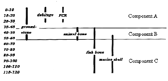
Figure 3.
Vertical
sequence of finds at Lan-206.
Component B use of the location seems to be characterized
by the introduction of more milling equipment and a decrease in
shellfish gathering. Chipped stone scrapers are first found in
this component. Fishing is indicated but the dramatic increase
in animal bone suggests a new emphasis on hunting. Game
included most of the large and small animals available in the area as
well as marine mammals. Component B may relate to an earlier
phase of the Intermediate Period (perhaps the first millennium B.C.)
The finds associated with Component A reflect the most
intensive knapping activity the site experienced (the only projectile
point known from the Berger site was found on the surface of
Component A). Milling equipment is frequent and abundant
fire-cracked rock suggests considerable roasting although animal
bone, fish bone, and shellfish valves are sparse. Obsidian
comes into use in Component A. The single obsidian hydration
date from the site came from an obsidian flake which was found at a
depth of 100 cm. We think that this flake attained that depth
through disturbance and that the hydration date of circa A.D. 200
should be associated with Component A. Assuming this
interpretation is correct, Component A should be associated with the
late Intermediate Period (first half of first millennium A.D.).
It is important to recognize that the characteristics
just described relate only to the use of the Berger site in
particular. Since different people may have used the location
for different purposes, the features of the components may not
accurately reflect cultural characteristics in general.
On the other hand, micro-cores and small drills are also
characteristic of nearby sites closer to the edge of the bluff.
The Marymount site (LAN-61), Del Rey site (LAN-63) and Bluff site
(LAN-64) all produced these types of tools and it seems reasonable to
conclude that they are a feature of the culture inhabiting the area
sometime following the close of the Millingstone Period.
In summary, it appears that the Berger site was in use by
around 4500 B.C. and that fish and shellfish consumption were
prominent activities on the hilltop during the early period.
The distribution of shellfish valves indicates that this early use
was probably confined to the highest elevation of the hilltop.
At some unknown time represented by the 50 cm. point in the vertical
sequence, marine shell gathering ceased to be of importance to the
site's users. While fishing did remain important, increased
animal bone suggests that there was a new emphasis on hunting.
Finally, during the latest period of the site's use, manufacture of
chipped stone implements, most notably micro-cores and scrapers, and
use of milling equipment become prevalent.
V. INVESTIGATIONS AT LAN-206A ON THE NORTH SLOPE (WEST
BLUFF PROPERTY)
In 1986, the excavation team working on the Del Rey and
Bluff sites (LAN-63 & 64), conducted an investigation of the
north slope scatter of the Berger site which they designated
"LAN-206A." The investigation was largely restricted
to that portion of the scatter which was within the boundaries of the
West Bluff property. Thus, the work took place northeast of the
main site. The purpose of the investigation was to determine
whether a significant deposit was present (pursuant to the provisions
of the California Environmental Quality Act [CEQA]). The
project consisted of plotting the surface scatter and excavation of
three 1 x 1 m. square test units (fig. 4).
A. Surface Scatter at LAN-206A
The surface scatter was plotted by walking the slope in
parallel transects and pin-flagging all cultural material found.
The pin flags were then located using transit and stadia (for details
regarding the method, see Van Horn and Murray 1982). Cultural
material was found to be scattered over an area measuring
approximately 90 m. N-S by 75 m. E-W.
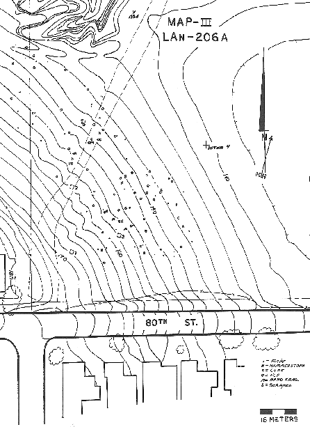
Figure 4.
LAN-206A
site map indicating locations of units and distribution of surface
finds.
Since the principal purpose of the mapping program was to
determine the best places to excavate test units, only unique or
particularly interesting items were collected (a large collection of
artifacts with secure proveniences had already been assembled during
the excavations at the main site).
The results of the mapping program may be seen in Figure
4. The scatter was found to consist of the following items:
54 Flakes
47 Fire-cracked rocks
10 Hammerstones
9 Cores
3 Mano fragments
2 Scrapers
Total 125 items
The map shows that the scatter extended from 80th
Street all the way down to the top of an arroyo which cuts through
the bluff at the northwest corner of the West Bluff property, a
distance of about 100 m. However, the pattern of the scatter
appears to have a radius which conforms to the slope. The
scatter did not extend all the way to the southern property boundary
(80th Street) but it is believed that this portion may have been
disturbed by construction of the road.
Because the slope has been cultivated and disced for
decades, movement due to mechanical forces and erosion have
undoubtedly "smeared" the original pattern.
Nonetheless, the general configuration of the scatter conforms to
what one might expect.
All of the cultural material types observed on the
surface are commonplace in the area and could be found in association
with sites of any date. However, the presence of an obsidian
flake and three pieces of ochre (found after the plot was completed)
suggests that some, if not all, of the cultural material at LAN-206A
should be associated with the latest use of the Berger site.
B. Test Excavation Units
Three 1 x 1 m. test units were excavated at LAN-206A at
the locations shown in Figure 3. Units 2 and 3, the more
outlying test locations, yielded almost nothing (all three levels of
Unit 2 were sterile; Unit 3 yielded 4 Monterey chert flakes in the
0-10 cm. level, 1 quartzite flake in the 10-20 cm. level and nothing
between 20 and 40 cm.). The finds from Unit 1 are summarized in
Table 10.

The excavators of Unit 1 noted evidence of considerable
rodent activity. They also recorded finding bottle glass
fragments as deep as 30 cm., a point where the soil color lightened
perceptibly.
C. Interpretation of LAN-206A
It seems reasonable to conclude that LAN-206A represents
a peripheral scatter of material relating to the later phases of the
Berger site (Components A and/or B). The strongest evidence
favoring this interpretation is the configuration of the scatter on a
slope which once ascended to the hilltop where Berger site activity
was concentrated (southwest corner of 80th Street and Berger Place).
The complete absence of marine shell at LAN-206A suggests
that the scatter relates to the later use of Berger since marine
shell is plentiful in the earliest component (Component C). The
presence of a single obsidian flake and three pieces of ochre in the
scatter also suggests that it relates to the later components of
Berger.
The results from Units 2 and 3 show that almost no
cultural material lies buried in the outlying area of the scatter.
Unit 1, which was placed upslope (i.e., closer to the hilltop),
yielded a small amount of cultural material but most of this was
found in the upper 30 cm., well within the plow/disc zone.
Faunal material was too sparse to suggest habitation at LAN-206A.
REFERENCES CITED
Abbott, R. Tucker
1968 Sea Shells of North
America. Golden Press. New York.
Allen, Larry G.
1985 A Habitat Analysis of the
Nearshore Marine Fishes From Southern California. Bulletin
of the Southern California Academy of Sciences 84 (3):133-155.
Brown, Robert S. & John R. Murray
1983
Archaeological Test Report: A 30+ Acre Parcel of Property at
the Corner of Manchester and Hastings Avenues in the City of Los
Angeles. Unpublished report on file with Archaeological
Associates. Sun City.
Colby, Susan M.
1986 The Faunal Remains (other
than fish), LAN-206. Unpublished report on file with
Archaeological Associates. Sun City.
Eberhart, Hal
1961 The Cogged Stones of
Southern California. American Antiquity, Vol. 26:361-370.
Herring, Alika K.
1968 Surface Collections from
Ora-83, A Cogged Stone Site at Bolsa Chica, Orange County,
California. Pacific Coast Archaeological Society Quarterly,
4(3)3-38. Costa Mesa.
Lambert, Vince
1983 A Surface Collection from
the Del Rey Hills. Journal of New World Archaeology, Vol. V,
No. 3. The Institute of Archaeology. University of California,
Los Angeles.
Meighan, Clement W.
1978 Obsidian Dating of the
Malibu Site. IN: Obsidian Dates II: A Compendium of the
Obsidian Hydration Determinations made at the UCLA Obsidian Hydration
Laboratory. Clement W. Meighan and P. I. Vanderhoeven
(eds.). Monograph VI. University of California Los
Angeles, Institute of Archaeology, pp.158-162.
Morris, Percy A.
1966 A Field Guide to
Pacific Coast Shells. Houghton Mifflin Company.
Boston.
Pence, Robert L.
1979 Archaeological Assessment
of the Summa Corporation Property, Culver City, Los Angeles County,
California. Unpublished report on file at the Archaeological
Survey, University of California, Los Angeles.
Reish, Donald J.
1972 Marine Life of
Southern California Emphasizing Marine Life of Los Angeles and Orange
Counties. Donald J. Reish, publisher. Los Alamitos.
Salls, Roy A.
1980 The La Brea Cogged Stone.
The Masterkey, 54(2):53-59.
1986 The Fish Fauna from the Berger Site (LAN-206),
Los Angeles, California. Unpublished report on file with
Archaeological Associates. Sun City.
Thiel, Marlys
1953 Recording by Pictures the
Collection of William Deane of the Hughes Aircraft Site.
Unpublished paper on file at the Archaeological Survey, University of
California, Los Angeles.
Van Horn, David M.
1983 A 30+ Acre Tract at the
Northwest Corner of Manchester and Hastings Avenues in the City of
Los Angeles. Unpublished report on file with Archaeological
Associates. Sun City.
Van Horn, David M. and John R. Murray
1982
Notes on Transit Controlled Surface Collection. IN:
Practical Archaeology Field and Laboratory Techniques and
Archaeological Logistics. Archaeological Research Tool
Vol. 2. Institute of Archaeology. University of
California, Los Angeles.
1985 The Loyola Marymount Archaeological Project:
Salvage Excavations at LAN-61A-C. Unpublished report on file
with Archaeological Associates. Sun City.
Wallace, William J.
1978 Post-Pleistocene
Archaeology, 9,000 to 2,000 B.C. IN: Handbook of North
American Indians, Vol. 8 (California; R.F. Heizer, ed.).
Smithsonian Institution. Washington, D.C.
Whitney-Desautels, Nancy A.
1995 Synopsis
Reports: CA-ORA-85: The Eberhart Site, CA-ORA-83: The Cogged Stone
Site, History of the Development of Conclusions. Unpublished
report on file with Scientific Resource Surveys, Inc. Temecula.